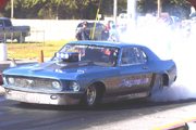
Here's a link to some photos I took at the Clarenville, NL, dragway this past weekend (July 26 & 27, 2008). Click on the thumbnails for larger images and you may need to click again on that image to see the photo at full resolution. See the "Photo Notes" at the bottom of the web page for a full explanation.
http://www.JustPhotos.ca/galleries/spor ... /20080727/
Mardon
Clarenville Drag Racing Photos
-
Rapid Randy Baker

- Posts:8075
- Joined:Thu Feb 23, 2006 9:05 am
- Location:Des Moines, Iowa
- Contact:

Great photos. Thanks for posting them and welcome! bp
Bill Pratt
Draglist.com - Crowdsourced drag racing history.
Headlines and Results: http://www.draglist.com/
Drag Lists: http://www.draglist.com/draglist/draglist.php
Draglist.com - Crowdsourced drag racing history.
Headlines and Results: http://www.draglist.com/
Drag Lists: http://www.draglist.com/draglist/draglist.php

Thanks & More Info
Thanks to everyone for the positive feedback.
Here's some more info in case anyone is interested.
The Clarenville Dragway is a 1/4 mile strip that runs every other weekend during the summer and early fall. It uses a 3,900 foot long, 75 foot wide, operational airstrip (C-CZ3) that is closed to all but emergency traffic during the weekend Meets. If there is an emergency, there's a mad dash by everyone (drivers and crew) to remove the cones and timing devices so that the aircraft can land. It happened once for a Medivac flight during the meet that I photographed; albiet outside racing hours.
You can easily see the track in Google Earth. The start line is at these coordinates: 48.27221N 53.92981W (WGS84). The track (and Newfoundland) is not as far north as some people think it is. In fact, the track is 32 miles further south than Bellingham, WA, in the U.S.
The racing chute shots are soft because the track has no safety barriers and I had to be far away. For that shot, I was 0.5 Km down the track from the finish line and about 0.3 Km from the car's location. My longest lens is a Canon 300 f/2.8 IS so I had stacked a 1.4x TC and a 2x TC for that shot. This alone makes for a soft image and then the heat off the track was causing lots of waves in the atmosphere, so that didn't help. On the other hand, I figured a soft shot of the chutes was better than no shot of the chutes.
The Ski-Doo run shown in image
http://www.JustPhotos.ca/galleries/spor ... 025689.jpg
was 9.7 seconds for the quarter mile, hitting 137 mph at the finish.
Thanks, Mardon. Great stuff! bp
Bill Pratt
Draglist.com - Crowdsourced drag racing history.
Headlines and Results: http://www.draglist.com/
Drag Lists: http://www.draglist.com/draglist/draglist.php
Draglist.com - Crowdsourced drag racing history.
Headlines and Results: http://www.draglist.com/
Drag Lists: http://www.draglist.com/draglist/draglist.php
Photos
Mardon,
Welcome to draglist and I plan to look at all your photo gallaries.
I will e mail you off group as I am one of several photo wannabe's on this site.
Iowa Al
Al Booton
alanhomer@aol.com
Welcome to draglist and I plan to look at all your photo gallaries.
I will e mail you off group as I am one of several photo wannabe's on this site.
Iowa Al
Al Booton
alanhomer@aol.com
-
Maritime Drag Racing
Great pics! Lots of familiar cars(and faces) from this part of the country. Passed that red first gen Camaro on the highway Tuesday morning. There was a mural of it on the back door of his trailer - at first glance I thought his back door was missing but when I got behind him I realized it was just a very clever graphic.
Who is online
Users browsing this forum: No registered users and 31 guests